Ho Chi Minh City has adjusted urban planning to develop riverside infrastructure by 2040, including a road along the Saigon river from district 1 to outlying Cu Chi district.
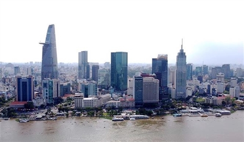 |
| A view of Saigon River in Ho Chi Minh City. The city plans to build a road along the river connecting downtown District 1 and outlying Cu Chi District.__Photo: Thanh Vu/VNA |
Standing Vice Chairman of the HCM City People’s Committee Le Hoa Binh has instructed the Department of Planning and Architecture to adjust the city urban planning to include multi-purpose infrastructure along the Saigon river.
“The move aims to improve the scenery and public utilities along the river, and reinforce the city’s capabilities in addressing floods, erosion global warming,” he noted.
Director of the Department of Planning and Architecture Nguyen Thanh Nha said the Saigon river passes through the center of the city where many commercial activities and services already exist, and has the potential for economic services.
The riverside area should primarily be a space for public activities and entertainment services for residents and tourists, he said.
The river’s banks have 3,100-5,000ha of land which could be used to plant trees, build traffic infrastructure and public spaces, and provide space for businesses, he said.
Architect Ngo Viet Nam Son said riverside areas could be used to develop public spaces, something the city lacks, and transportation, parking and amusement.
The city has a total of nearly 8,000 kilometers of rivers, canals and channels, accounting for around 16 percent of its area.
Binh called on other agencies such as the departments of construction, natural resources and environment, transport, and agriculture and rural development to offer their opinions on the adjustments to the urban plan.
He urged the Department of Planning and Architecture to complete the changes to urban planning for Thu Duc city, a newly created administrative area, for submission to the Government in June.
He also instructed it to complete plans for major urban projects approved by the People’s Committee and submit for approval.
They include industrial infrastructure development by 2045, the design for Le Loi boulevard and the Ben Thanh metro station, and the project to improve the urban landscape along Xuyen Tam canal, he said.
For the 2,870ha Can Gio sea encroachment project, the department should ensure people have full access to public beaches, he said.
Nha said this year his agency would review and adjust plans for Tan Son Nhat International Airport and areas along ring road Nos. 3 and 4.
“Inconsistency has created conflicts in urban plans,” he admitted.
President Nguyen Xuan Phuc recently urged the city to develop long-term urban plans to ensure sustainable growth amid the fast pace of construction, high population density and environmental pollution.
He called on it to become “a smart and developed city that promotes the cultural identity of the southern region in its urban planning.
“To do so the urban planning must be consistent with its long-term targets and orientations,” he said.-(VNS/VLLF)