Phan Duc Hieu[1], Ph.D, and Nguyen Van Thao, MSc.
The Law on Survey and Mapping (the Law), adopted in 2018 and effective from the beginning of this year, contains many important provisions relating to foreign entities that participate in survey and mapping activities in the territory of Vietnam.
General provisions to be observed by foreign entities
The Law applies to agencies, organizations and individuals engaged in survey and mapping activities, exploiting and using survey and mapping information, data and products, or carrying out other related activities in the territory of Vietnam. So, when conducting survey and mapping activities in Vietnam, foreign entities must comply with the Law.
Article 4.1 of the Law says survey and mapping activities are to be carried out on the principles of ensuring national sovereignty, unity, territorial integrity, national defense and security, and social order and safety. These activities must also meet the country’s international integration requirements and conform to treaties to which Vietnam is a contracting party.
The above provision stresses the importance of the protection of territorial sovereignty and integrity of the country in survey and mapping activities, whether they are performed by domestic or foreign organizations or individuals. This is reaffirmed in Clauses 1 and 2, Article 18 of the Law, which state: “The national boundaries and territorial sovereignty must be accurately represented in survey and mapping products and map publications; and organizations and individuals must use standard national boundary maps or national boundary maps provided by the Ministry of Natural Resources and Environment for areas without standard national boundary maps to accurately represent the national boundaries and territorial sovereignty on survey and mapping products and map publications.”
The aforesaid contents are specified in Circular 17 of 2018 of the Ministry of Natural Resources and Environment (MONRE) providing technical regulations on making and updating standard national boundary maps and accurately representing the national boundaries and territorial sovereignty on survey and mapping products and map publications.
At present, the MONRE is working out on a set of standard national boundary maps. Once completed, these maps will be made public to all related entities, including foreign ones.
The Law’s requirement for uniform use of the set of standard national boundary maps in making geographic databases and map publications aims to ensure that the national boundaries between Vietnam and neighboring countries are represented strictly according to Vietnam’s regulations and the documents signed by Vietnam and these countries.
Concerning standardization of geographical names and use of standardized geographical names, Article 21 of the Law requires all organizations and individuals to use geographical names standardized and publicized by the MONRE in survey and mapping activities in each period as appropriate. The standardization of geographical names must meet the requirements of continuity, universality, integration, respect for local beliefs and customs, and conformity with linguistic rules. At the same time, the standardized geographical names must be compatible with geographical names prescribed by Vietnam’s law or used in treaties to which Vietnam is a contracting party.
So far, the MONRE has mostly completed the standardization of geographical names on the land of the territory of Vietnam to serve the drawing of national topographic maps of a 1:10,000 scale and smaller scales. By April this year, the ministry has issued 54 circulars announcing the lists of geographical names of 54 provinces and centrally run cities. It is expected that by 2020, nine more circulars will be issued to promulgate the lists of geographical names of the remaining localities.
Article 6 of the Law prohibits the following acts in survey and mapping activities:
- Forging or falsifying survey and mapping data and results;
- Destroying or damaging survey infrastructure works; or encroaching upon protection corridors of survey infrastructure works;
- Carrying out survey and mapping activities while failing to fully meet the law-prescribed conditions;
- Publishing or circulating survey and mapping products or map publications related to national territorial sovereignty without representing national sovereignty or boundaries or incorrectly representing national sovereignty or boundaries;
- Obstructing lawful survey and mapping activities of agencies, organizations or individuals;
- Taking advantage of survey and mapping activities to infringe upon national interests or lawful rights and interests of organizations or individuals; and,
- Spreading or revealing survey and mapping information, data or products on the list of state secrets.
According to Article 59.2 of the Law, violators will, depending on the nature and severity of their violations, face administrative sanctions, discipline or criminal prosecution; if causing damage, they must pay compensations in accordance with law.
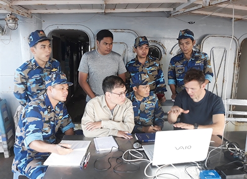 |
| Foreign experts provide instructions on new technologies serving the drawing of nautical charts__Photo: https://baohaiquanvietnam.vn |
Foreign investment in survey and mapping activities; and use of survey and mapping information, data and products by foreign entities
The state policies on survey and mapping set out in Article 5 of the Law are expected to help domestic and foreign entities invest or participate in survey and mapping activities and use survey and mapping information, data and products on the condition that they abide by the law and refrain from doing anything harmful to the national territorial sovereignty of Vietnam. Accordingly, organizations and individuals, both domestic and foreign, are encouraged to invest in, and conduct research into and application of sciences and high, advanced and new technologies. They will be welcomed in training and developing highly qualified human resources in the field of survey and mapping. They will also be provided with favorable conditions to access, exploit and use survey and mapping information, data and products as well as national geospatial data infrastructure and to participate in survey and mapping activities. Below are some specific policies:
Investing, building, managing the operation of, maintaining or operating survey infrastructure works
Article 14 of Government Decree 27 issued in March 2019 detailing a number of articles of the Law (Decree 27) says that organizations and individuals may invest, build, manage the operation of, maintain or operate survey infrastructure works according to the list of investment projects announced by the MONRE and relevant laws.
Under Clause 4 of this Article, investment projects to build survey infrastructure works must comply with the investment law and guarantee the interests of the State and investors while protecting the national defense and security of Vietnam.
Survey and mapping licenses
The grant of survey and mapping licenses for foreign contractors is prescribed in Clauses 2 and 3 of Article 51, and Article 52, of the Law, and the order and conditions for grant of a license are specified in Article 32 of Decree 27. Under these articles, a foreign contractor may be granted a survey and mapping license by the MONRE when it fully meets the law-prescribed conditions. This contractor may only carry out survey and mapping activities in the geographical area of operation and a validity period equal to the period of implementation of survey and mapping contents in the relevant bidding package as stated in the license.
If allowed to prolong the period of execution of a bidding package, the project owner may request the extension of its survey and mapping license if the survey and mapping jobs in such bidding package have not yet been finished.
Provision of survey and mapping information, data and products
Article 41.3 of the Law specifies which survey and mapping information, data and products may be widely provided for foreign entities to use in compliance with Vietnam’s laws on charges and fees, protection of state secrets, and intellectual property rights, etc. Meanwhile, Article 22 of Decree 27 specifically regulates the exchange and provision of survey and mapping information, data and products to international organizations and foreign organizations and individuals.
International cooperation on survey and mapping
Principles of international cooperation on survey and mapping are laid down in Article 8.1 of the Law, such as ensuring national independence, sovereignty, unity and territorial integrity of Vietnam; complying with treaties to which Vietnam is a contracting party and Vietnam’s law; and ensuring equality and mutual benefit.
Meanwhile, Article 8.2 of the Law defines specific contents of international cooperation on survey and mapping. These include concluding, and organizing the implementation of, treaties and international agreements on survey and mapping; and implementing international cooperation programs and projects. Other contents are exchanging experts; training human resources for survey and mapping activities; conducting scientific research and application and transfer of technologies in survey and mapping; exchanging survey and mapping information, data and products; and participating in and hosting international conferences, seminars and talks.
Conclusions
The Law on Survey and Mapping and its implementing regulations offer a favorable legal corridor for foreign entities to invest and participate in survey and mapping activities in the country on the basis of abiding by Vietnam’s law and treaties to which Vietnam is a contracting party or has acceded. They also demonstrate the country’s integration into international activities in the survey and mapping sector in the context of the ongoing Fourth Industrial Revolution in the world.-