On October 5, 2019, Vietnam and Cambodia signed the two legal agreements on recognizing 84 percent of the delimitated and demarcated boundary land between the two countries. This article highlights the process of the Vietnam-Cambodia boundary settlement in accordance with international law.
Nguyen Hong Thao, Assoc. Prof. in Law
Diplomatic Academy of Vietnam
After restarting the process of land border demarcation and marker planting under the 2005 Supplementary Treaty to the 1985 Treaty on the Delimitation of National Boundaries between the Socialist Republic of Vietnam and the Kingdom of Cambodia, on October 5, 2019, in Hanoi, in the presence of Vietnamese Prime Minister Nguyen Xuan Phuc and his Cambodian counterpart Hun Sen, a Supplementary Treaty to these two treaties and a protocol on land border demarcation and marker planting between the two countries were signed. These two new documents officially affirm the achievement of the demarcation and marker planting of 1,042 km out of 1,137 km (84 percent) of the border between the two nations.
Background
As two neighbors with a long-age history of relations, Vietnam and Cambodia share a land border of 1,137 km long passing through 10 border provinces of Vietnam and nine border provinces of Cambodia. During feudal dynasties, Vietnam and Cambodia formed historical borders but only at zone-regional level (zone borders). During the colonial period, their border consisted of two parts. The border section between Cochinchina and Cambodia, which was delimited under the France-Cambodia Agreement in 1870 and the France-Cambodia Treaty in 1873, was determined as an international border of which there are few remaining traces today. The border section between Central Vietnam and Cambodia has no delimitation documents, except decrees defining the administrative limits of Vietnam’s central provinces, which, however, were not demarcated. These two border sections were drawn by the French administration on 26 pieces of the 1:000,000 scale Bonne map published by the Indochinese Geography Department in different years.
During the 1954-75 period, sea and land border disputes regularly occurred between the Saigon regime and Cambodia. In the years from 1964 to 1967, when Cambodia proclaimed to be a neutral nation, the National Front for Liberation of South Vietnam and the Government of the Democratic Republic of Vietnam issued declarations recognizing Cambodia’s sovereignty and territorial integrity within its then “existing boundary line”. In 1964, 1966, 1975 and 1976, the two countries conducted a number of discussions and negotiations on border issues but no agreement was reached.
After the birth of the People’s Republic of Cambodia, on February 18, 1979, the Government of the Socialist Republic of Vietnam and the Government of the People’s Republic of Cambodia signed the Treaty of Peace, Friendship and Cooperation between the two countries. Article 4 of the Treaty states: “(the two countries) will conduct negotiations for signing a border delimitation agreement on the basis of the existing boundary line and be determined to work together to build it into the one of long-lasting peace and friendship.”
On July 20, 1983, the two countries signed a treaty on the principles for resolving their border issues: (1) On land, the two sides agree to consider the existing border line between the two countries illustrated on the 1:100,000 scale map published by the Indochinese Department of Geography before or closest to 1954 (including 26 pieces recognized by the two sides) as the national border line between the two countries; (2) for those areas which were not marked on the map or not agreed to by the two countries, both sides will negotiate to reach solutions in the spirit of equality and mutual respect for their special relationship, and compliance with international law and practice.
In order to have a ground for the management and maintenance of stability along the border pending the delineation of an official and clear border between the two countries, on the same day of July 20, 1983, the two nations signed an agreement on the Vietnam-Cambodia border regulations. Article 1 of the regulations states: “Pending the official delimitation the national border line between the Socialist Republic of Vietnam and the People’s Republic of Cambodia is the existing border line illustrated on the 1:100,000 scale map published by the Indochinese Department of Geography before or closest to 1954 as stipulated in Article 1 of the 1983 principle treaty”.
Regarding border rivers and streams, Article 8 of the regulations says: “For rivers, streams, canals or drains belonging to one country with the boundary line running along one river side, inhabitants living in the boundary zone of the other country may still use water in such rivers, streams, canals or drains for their daily life and ships and boats may navigate but fishing is banned. The building of medium and major irrigation works on these border rivers, streams, canals or drains must be discussed and agreed upon by provincial administrations of the two countries and reported to the two governments for decision.”
Under the principles agreed in the 1983 Treaty, the two countries negotiated and signed a Treaty on the Delimitation of National Boundaries between Vietnam and Cambodia on December 27, 1985. This treaty was later ratified by the State Council of the Socialist Republic of Vietnam on January 30, 1986, and by the Parliament of the People’s Republic of Cambodia on February 7, 1986. This Treaty came into force on February 22, 1986, after the two sides exchanged their ratification instruments in Hanoi.
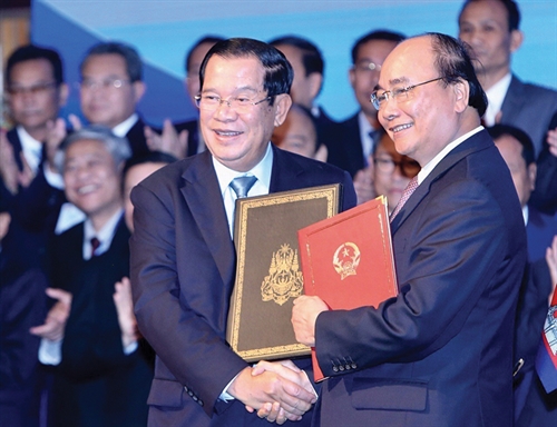 |
| Prime Minister Nguyen Xuan Phuc (right) shakes hands with his Cambodian counterpart, Samdech Techo Hun Sen, after signing the Supplementary Treaty to the 1985 Treaty on the Delimitation of National Boundaries and the 2005 Supplementary Treaty between Vietnam and Cambodia__Photo: Duong Giang/VNA |
According to Article 1 of the 1985 Treaty, the two countries’ land border line is shown in detail on the 1:50,000 scale UTM map of the US army (converted from the border line shown on the 1:100,000 scale Bonne map). These two kinds of maps, the Bonne and UTM, are attached to the Treaty and of equal validity. The Treaty also deals with issues related to border rivers, streams, canals and ditches, saying that regardless of the change of the course of border rivers and streams, the border remains unchanged; islets and alluvial banks along the border rivers and streams of either country will belong to that country; and for border bridges, the border line will be their middle line.
Thus, the 1985 Treaty clearly demonstrates the two countries’ respect for the existing border line and agreement to use the map published by the colonial administration and US Army UTM map for border demarcation and marker planting work. Under the Treaty, most of the Vietnam-Cambodia land border was delimited, with only a few points the two sides agree to settle in the field.
After the 1985 Treaty came into force, the two sides demarcated more than 200 km out of a total of 1,137 km of the shared border line and planted 72 markers among 322 planned ones. In 1989, the demarcation process was suspended due to Cambodia’s internal problems.
In 2005, the two countries wished to sign a supplementary treaty to the 1985 Treaty in order to recognize some adjustments to meet the new situation and resume demarcation and marker planting work. Reasons for signing a supplementary treaty include reviewing the drawing, creating a new map, adjusting some areas according to actual management, and changing the principles related to border rivers and streams.
Firstly, the application of the map principle is a judicious decision of the two countries, but when selecting and applying the map, the two sides have no choice but accept some limitations in the practical implementation. Since the Bonne map was published in different years from 1951 to 1954, its content and quality are incomplete. Some of its pieces were temporarily drawn while some others have blank parts or broken boundary lines. Its scale of 1:100,000 is too small. As printed in the 1950s, it did not match the changing terrains. Moreover, the recognition that these two kinds of maps were of equal validity in demarcation and marker planting work caused difficulties to the demarcation in areas where there are discrepancies between the maps and between the map and the actual geographical conditions, especially in the flood-frequented Mekong Delta region. The two countries need to review and reach agreement to ensure no blank parts on the maps and to build a new map showing the demarcation and marker planting line.
Secondly, regarding border rivers and streams, according to international law and State practices around the world, the border line often follows the deep channel (thalweg) of navigable rivers and streams or the median line of the main course of non-navigable ones. During the negotiation of the 1985 Treaty, Vietnam proposed to apply such method, but Cambodia insisted on following the map drawn by the French. There is a reality that there are some river sections entirely managed by Vietnam and some others wholly managed by Cambodia, leading to conflicts over the use of water sources between border inhabitants of the two countries. After 20 years of management and use of border rivers and streams, the Cambodian side recognized that the regulation on the border line running on one river bank caused inconveniences in the management and use of water sources for both sides. They admitted that Vietnam’s previous proposal was more appropriate and wished to readjust the border line along rivers and streams according to international law and practice. This change is also in line with other international law principles of shared use of water resources, environmental protection and sustainable development, especially when both countries are members of the Mekong River Commission. Vietnam also worked with Laos and China to handle border rivers and streams according to the thalweg or median line principle.
Thirdly, the two sides have the need to reaffirm the significance of the 1985 Treaty to rebuke the “hostile forces” allegations aiming to sow division between the two peoples and demand the abolition of the Vietnam-Cambodia border treaties and agreements signed in the 1980s.
Fourthly, the two sides share the goal of resuming demarcation and marker planting work to build a common border of peace, friendship, stability and development cooperation.
The Supplementary Treaty to the 1985 National Boundary Treaty was signed in Hanoi on October 10, 2005.
The 2005 Supplementary Treaty affirms the value of the 1985 Treaty, considering itself to be only supplementary to the former. Article III, Section 4, and Article IV, Section 1, of the 2005 Supplementary Treaty assert the two sides’ determination to “soon complete the demarcation and marker planting process” and stipulate that the two sides will approve the master plan on demarcation and marker planting before the end of 2005, and strive to complete the demarcation and marker planting work before December 2008. The two sides agree to apply the following international principles and practice on border rivers and streams to demarcate the border rivers and streams throughout the land border line between the two countries:
- For non-navigable sections of border rivers and streams, the border line will be the median line of the principal course of such a river or stream.
- For navigable sections of border rivers and streams, the border line will follow the median line of the principal navigable channel.
To protect the interests and stability of the people living on the river sides, and to avoid great changes especially in the Mekong Delta region, the two sides agree to include in the Supplementary Treaty the provision: “In case of difficulties arising in the application of the above provisions, the two Parties shall hold friendly exchanges to find a solution acceptable to both.”
The two sides agree to settle six points temporarily agreed in the 1985 Treaty. Three areas (area 1 in Kon Tum province bordering on Cambodia’s Ratanakiri province, area 2 in Gia Lai province bordering on Ratanakiri province, and area 3 in Dak Lak province bordering on Mondulkiri province) share the same characteristics of having dense forests and high mountains not clearly shown on the Bonne map attached to the 1985 Treaty, as well as being unoccupied on both sides of the border. After conducting joint field surveys, the two sides agree to readjust the border line in these areas based on topographic factors. There are other three areas between Vietnam’s An Giang province and Cambodia’s Kandan province, which have long been managed by either Vietnam or Cambodia but are not shown on the 1985 Treaty map. The two sides agree to readjust them to suit the real management situation.
The 2005 Supplementary Treaty meets the mutual concerns and interests of the two countries, further raising the Vietnam-Cambodia relationship to a new height, under the motto “Good neighborhood, traditional friendship, comprehensive cooperation and long-term sustainability.” The treaty has paved the way for the demarcation and marker planting process to progress toward a long-term stable border in line with international law.
Demarcation and marker plantation (abornement) of Vietnam-Cambodia border
Implementing Article 4 of the 2005 Supplementary Treaty, the two sides established a Joint Demarcation and Abornement Committee to plant markers along the shared land border. The Chairman of the Joint Committee on the Cambodian side is Senior Minister Var Kim Hong, Chairman of the National Border Committee. On Vietnam’s side, it is a Deputy Foreign Minister cum Chairperson of the Border Committee. According to Article 2.1 of the Regulation on the Joint Committee, signed on December 22, 2005, it is tasked to “organize the border demarcation and marker planting on the Vietnam-Cambodia land border; at the same time, based on the 1985 Treaty and the 2005 Supplementary Treaty together with the maps attached to the 1985 Treaty and the 2005 Supplementary Treaty Annex, to determine in the field the direction of the border line from the T-junction point between the Socialist Republic of Vietnam, the Kingdom of Cambodia and the People’s Republic of Laos to the tip of the border line on the coast between Kien Giang province (Vietnam) and Kampot province (Cambodia)”.
The two sides organized a number of teams to carry out demarcation and marker planting activities in the field, with Cambodia setting up seven teams for nine provinces and Vietnam having 11 teams for 10 provinces. Due to difficulties arising in organization work, maps, reviewing and drawing, building of markers in flooded areas, and thickening of additional markers as required by the Cambodian side, the demarcation and marker planting work could not be finished according to the set deadline. On September 27, 2006, the two sides solemnly held an inaugural ceremony for marker No. 171 at the pair of international border gates of Moc Bai (Tay Ninh province) and Bavet (Svay Rieng province) to the witness of the Prime Ministers of the two countries. This was the first marker officially restarting the demarcation and marker planting process, after a pause since 1989.
Since 2006, the Joint Committee has:
- Reviewed and transferred about 90 percent of the total length of the border line (about 1,042/1,137 km) from the 1:100,000 scale Bonne map to the 1:50,000 scale UTM map to serve demarcation and marker planting work.
- Identified and built 315 out of 371 major markers, including a marker at the Vietnam-Laos-Cambodia border junction, the marker with the last serial number 314 on the border line, great markers with the national emblem at all 10 pairs of international border gates, markers at most of the main border gates…
- Built 1,511 out of 1,512 auxiliary markers and 221 additional posts between the main markers in the fully demarcated areas in order to further clarify the direction of the border line, as requested by the Cambodian side.
- Finalized the records of demarcation and marker planting results as of December 2018, consisting of: (i) records of marker planting (ii) table of registered markers; (iii) table of elevation coordinates of markers; (iv) table of specifications of dunes on border rivers and streams; and (v) a written description of the direction of the border line.
- Hired a third party (BlomInfo A/S company of Denmark) to establish a new set of 1:25,000 border topographic maps to attach to the Protocol to record the demarcation and marker planting results. With Laos and China, Vietnam and related parties of these two countries built common border topographic maps. Meanwhile, at the request of Cambodia, Vietnam hired a third party to ensure objectivity for the mapping work.
- Exchanged and developed the following legal instruments: the Supplementary Treaty to the 1985 National Border Delimitation Treaty and the 2005 Supplementary Treaty and the Protocol on Land Border Demarcation and Marker Planting between the Socialist Republic of Vietnam and the Kingdom of Cambodia, which recognizes the accomplishment of 84 percent of the demarcation and marker planting workload.
In the process of demarcation and marker planting, the two sides have strictly determined and planted the markers in the direction of the border line which has been reviewed and drawn under the 2005 Supplementary Treaty. In the field, because the undelimited border line has existed for nearly a hundred years, there are some areas where local people and governments of the two sides have managed beyond the boundary drawn on the map, such as Vietnamese cultivating rice fields in the land under the management of Cambodia or Cambodian pagodas and President Heeng Xom Rin’s village lying in Vietnam’s land. In order to solve difficulties in the process of demarcation and marker planting and maintenance of the status quo, the land and gardens on which local people have farmed for ages, as well as creating favorable conditions for the livelihood of inhabitants along two sides of the border, on the basis of experiences accumulated from the settlement of border issues with neighboring countries, on April 23, 2011, on the occasion of Prime Minister Nguyen Tan Dung’s visit to Cambodia, the representatives of the two Governments signed a Memorandum of Understanding (MoU) on the Adjustment of the Land Border in a number of remaining areas between the Government of the Socialist Republic of Vietnam and the Royal Government of Cambodia. The land swap according to the MoU on the basis of fairness of area and interests helped clear the deadlock in the process of demarcation and marker planting. This approach maintains the actual management road in some areas, adjusts it in some other areas with the swapping of equivalent areas, contributing to ensuring the stable life and production of border inhabitants, meeting the common aspirations of local people and governments and enjoying the support from the peoples of both countries.
In the course of cooperation, Vietnam has helped and responded to the requests of Cambodia in the most impartial and objective manner. Vietnam helped Cambodia print five new sets of 40 pieces of the 1:50,000 UTM map, invited a third party to make border maps while the demarcation and marker planting of the Vietnam-Laos and Vietnam-China borders were all based on the topographic maps drawn by the two countries themselves. Vietnam agreed to further manage the border line under the Vietnam-Cambodia press release signed on January 17, 1995; should there be any discrepancy in the interpretation and implementation of the 2005 Supplementary Treaty, the two sides shall resolve it by peaceful means through discussion and negotiation. Vietnam also temporarily adjusted in a proactive manner the old French border line running along the Cambodian river bank to the middle of the flow so that people on both sides may have access to the water source.
The signing of the Supplementary Treaty and the Protocol in 2019 was not stated in the two documents. However, it can be seen that the demarcation and marker planting process took a long time, so after 14 years of implementation, the two countries can utilize the settled border section and create a momentum for resolving the remaining issues.
Significance of the signing of two new border documents
The Supplementary Treaty to the 1985 National Boundary Treaty and the 2005 Supplementary Treaty and the Protocol on land border demarcation and marker planting are two treaties that officially address 84 percent of the border line between Vietnam and Cambodia. These two documents will be deposited at the United Nations to guarantee the rights of the parties as prescribed. They reflect the aspirations and wills of the two countries and peoples in establishing a shared border line of peace, friendship and sustainable cooperation. For the first time, Vietnam and Cambodia have a basically complete international border line, marked by modern markers, creating favorable conditions for management and development cooperation.
The two documents affirm the value of the 1985 National Boundary Treaty and the 2005 Supplementary Treaty, which show the two countries’ persistency in the peaceful settlement of border and territorial disputes, and oppose the arguments of reactionary forces about the border situation. Speaking at the signing ceremony, Prime Minister Hun Sen said: “The great achievements that the two countries have achieved in the demarcation and marker planting work stem from our efforts to find a common solution based on friendship, brotherhood, mutual sympathy and being friends for decades.”
These two documents create conditions for Vietnam and Cambodia to continue to cooperate in resolving outstanding issues in the remaining 16 percent of the shared land border, including six areas where land swap has not yet been completed under the MOU signed in 2011 (five areas in Long An-Svay Rieng and one area in Gia Lai, Dak Lak-Rattanakiri, Mondulkiri); and seven border sections which have not yet been demarcated in the pairs of Gia Lai-Rattanakiri provinces; Dak Nong-Mondulkiri provinces; Tay Ninh-Svay Rieng provinces; An Giang-Kandal provinces; and Kien Giang-Kampot provinces. Prime Minister Nguyen Xuan Phuc said the leaders of the two countries will continue to direct and press for the early completion of the demarcation and marker planting on the entire border line, “based on mutual understanding, affection and responsibility between the two countries, respect for international law, especially relevant international agreements signed between our two countries”. The settlement of outstanding issues in the near future will make Vietnam the first country in Southeast Asia to have a complete land border registered at the United Nations, ending the seeds of border conflict and war left by history.
The two documents have contributed to bringing the policy of turning the land border into a trade border, contributing to boosting trade between the two countries.
The two documents were signed right on the occasion of the 30th anniversary of the Vietnamese volunteers returning home after fulfilling their international obligations to expel the Khmer Rouge, saving the people of Cambodia from genocide. They reaffirm the endeavor and friendship of the two nations for an eternal border. Prime Minister Nguyen Xuan Phuc said: “The solemn signing ceremony today is a declaration of two independent, sovereign nations, the Socialist Republic of Vietnam and the Kingdom of Cambodia, about their will and determination to cooperate and build a border of peace, friendship, cooperation and mutual development on the basis of respecting the territorial integrity and interests of each other, equality and mutual benefits, for the sake of happiness and prosperity of the peoples of the two countries.
The two documents also serve as a basis for the two countries to finish the demarcation and marker planting on the remaining border sections in the near future, thoroughly resolving the territorial border disputes which have existed for centuries, for the peace and friendship between the two countries and for the regional security and stability.-
__________________
References
1. The Ideology and Culture Commission and Border Committee - Ministry of Foreign Affairs, Questions and answers about legal documents on the demarcation and marker planting of the Vietnam-Cambodia border, National Politics Publishing House 2007.
2. Nguyen Hong Thao, “Legal aspects of the Supplementary Treaty to the 1985 Vietnam-Cambodia National Border Delimitation Treaty”, State and Law journal issue No. 8 (220)/2006, pp. 65-70.
3. Nguyen Hong Thao, “2011 - A pivotal year of the demarcation and marker planting work on the Vietnam-Cambodia land border”, Science and Strategy Journal issue No. 1 (January 2011) pp. 48-52.
4. Ramses A. &, Nguyen Hong Thao, “Managing Vietnam’s border disputes”, International Studies, Institute for International Relations No. 17, December 2005, pp. 26-38.
5. Ramses A. &, Nguyen Hong Thao, “Vietnam’s Border Disputes - Assessing the Impact on Its Regional Integration”, Vietnam’s New Order International Perspectives on the State and Reform in Vietnam, Edited by Stephanie Balme and Mark Sidel, Palgrave 2007, pp. 71-88.
6. Ramses A. &, Nguyen Hong Thao, “The Challenge of the Border Disputes of Cambodia, Laos, and Vietnam and Regional Conflict Management”, Society for Southeast Asian Studies (SEAS), The Austrian Journal of Southeast Asian Studies/Österreichische Zeitschrift für Südostasienwissenschaften (ASEAS) September 2009.