Phan Duc Hieu[1], Ph.D., and Nguyen Van Thao, MSc.
The Law on Survey and Mapping (the Law), adopted in June last year, contains six articles (Articles 43 thru 48) defining national geospatial data infrastructure (NSDI). Under the Law, the Government is assigned to prescribe in detail the building of NSDI. In implementation of this, the Government issued Decree 27 on March 13, devoting five articles to detail the aforesaid contents.
This is the first time NSDI has been specified in the country’s law, helping create an important legal foundation for building and developing NSDI.
General provisions on NSDI
According to Article 43 of the Law, NSDI is a collection of policies, institutions, standards, technologies, data and resources to share and effectively utilize geospatial data nationwide.
This Article states that NSDI must ensure that geospatial data are standardized and fully gathered from ministries, sectors, localities, organizations and individuals. Such data must be updated regularly to meet the requirements of state management, socio-economic development, and national defense and security maintenance; disaster prevention and control, rescue and salvage, remediation of environmental incidents, and climate change response; and improvement of people’s intellectual level. They must also facilitate the provision of public services; and assurance of connectivity with geospatial data infrastructure of countries in the region and the world.
It goes on to say that the provision, exchange, exploitation and use of geospatial data must not infringe upon the national interests and lawful rights and interests of organizations and individuals.
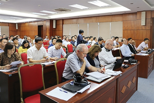 |
| Attendants at a workshop on legal framework for building Vietnam’s national geospatial data infrastructure in Hanoi on June 11__Photo by: Nguyen Van Thao |
Contents of building of NSDI
Article 44 of the Law lays down five contents of building of NSDI, covering:
(i) Formulating development strategies and implementation plans for the national geospatial data infrastructure;
(ii) Formulating mechanisms and policies and creating resources for organizing the materialization of development strategies and implementation plans for NSDI;
(iii) Selecting and developing technologies and formulating standards and technical regulations on NSDI;
(iv) Building and integrating geospatial data; and,
(v) Building and operating Vietnam Geospatial Portal and developing geospatial data applications and services.
Based on these contents, Decree 27 defines in Articles 24, 25 and 26 the formation of the strategy on development and plans on implementation of NSDI; policies and resources for the building and development of NSDI; and technologies, standards and technical regulations on NSDI.
Specifically, the NSDI strategy needs to conform with the national socio-economic development strategy and general master plan, ensuring that building and development of NSDI satisfy state management requirements and the requirements like those set out for geospatial data in Article 43 of the Law. NSDI must also serve the building of e-government, and facilitate the connectivity of geospatial data infrastructure facilities among ministries, sectors and localities.
The strategy will be designed every 10 years. Its contents must manifest viewpoints, vision, objectives, policies, tasks, resources, solutions for implementation, and assignment of tasks of organizing the implementation of the strategy. The Ministry of Natural Resources and Environment (MONRE) will, in coordination with other ministries, sectors and localities, formulate the strategy and submit it to the Government for approval.
Based on the strategy, the MONRE will take charge of and work with other ministries, sectors and localities in, making an overall plan for implementation of NSDI and submit it to the Prime Minister for approval. Meanwhile, ministries, sectors and localities will base themselves on tasks and responsibilities assigned in the strategy to organize the formulation and implementation of five-year and annual plans in conformity with the approved overall plan.
Regarding NSDI development policies, the State will invest in the building and development of NSDI to meet the requirements of state management, socio-economic development and national defense and security maintenance. In the meantime, ministries, sectors and People’s Committees at all levels will use NSDI in e-governments, socio-economic development planning, and natural resources, environment and land management. Organizations and individuals are encouraged to take part in building, accessing and using NSDI.
As per resources for NSDI building and development, the State will reserve funding to complete the building of framework data and specialized data; train human resources to meet the requirements of NSDI building and development; and research and develop high and advanced technologies in the collection, processing and building of geospatial data suitable to the NSDI development.
With regard to technology development and application, focus will be given to developing and improving the applications of satellite positioning technology, remote sensing technology, and ocean depth measurement technology so as to ensure fast, timely, accurate and efficient data reception, collection, updating and processing. The building of the system architecture of NSDI must also ensure connectivity of NSDI with the e-government system and ensure quick, simple and easy access to geospatial data. The application of cloud computing and artificial intelligence technologies will be stepped up in the provision of geospatial data and data services.
Standards and technical regulations on NSDI, including those on geospatial data and metadata, network architecture, network infrastructure, and geospatial data display, sharing, conversion, integration, search and downloading services, will be developed synchronously, thus ensuring the accuracy of data and facilitating the data connection, access and security.
Responsibilities for building and integration of national geospatial data
National geospatial data consist of six framework data groups and 12 specialized data groups. Each type of national geospatial data will be received, collected and updated by a single agency and be stored according to management decentralization regulations.
Framework data include data on national geodetic networks, national fundamental geographical data, national topographic maps, aerial photos, remote sensing images, standard national boundary maps, administrative boundary maps, and geographic names.
Specialized data are composed of cadastral data; data on land use status maps, water resources survey and assessment maps, geological and mineral maps, soil maps, forest status maps, underground works status maps, civil aviation maps; and data on charts of seaport waters, navigable passages and routes and maritime zones. They also cover map data on disaster prevention and control, rescue and salvage, remediation of environmental incidents, and climate change response, and data on traffic maps and planning maps of different types.
Framework data and specialized data are represented by metadata with information on scope, time, and entities building, updating and storing data; conformity with relevant standards and technical regulations; quality and legal validity of data; and methods of accessing, exchanging and using data-related services.
In regard to responsibilities for building national geospatial data and NSDI, Decree 27 states that the Prime Minister will instruct and coordinate the building of NSDI. The MONRE will organize the building of framework data, and thematic map data on water resources survey and assessment, geology, minerals, remediation of environmental incidents, and climate change response. The ministry will also be responsible for integrating national geospatial data.
The responsibility to build national-level planning and regional planning map falls on the MONRE, Ministry of Agriculture and Rural Development, Ministry of Construction, Ministry of Construction, and other related ministries and sectors within the ambit of their respective management.
In addition, the Ministry of Agriculture and Rural Development will organize the building of map data on soil, forest status, and disaster prevention and control.
In the meantime, the Ministry of Construction will arrange the building of provincial planning, special economic-administrative unit planning, urban planning and rural planning map data.
The Ministry of Transport will take charge of building map data on civil aviation, traffic and charts of seaport waters, navigable passages and routes, and maritime zones.
The building of data of charts of maritime zones and marine rescue and salvage will be organized by the Ministry of National Defense.
Provincial-level People’s Committees will organize the building of cadastral data and map data on land use status, underground works status, rescue and salvage, and provincial and special administrative-economic unit planning map data in their localities.
Organizations and individuals may take part in building and updating national geospatial data under Article 45 of the Law.
The Department of Survey, Mapping and Geographic Information of Vietnam under the MONRE will be the focal point in building NSDI while ministries and sectors will designate their focal bodies in building NSDI according to their respective responsibilities. Provincial-level Departments of Natural Resources and Environment will be the focal points in building NSDI according to the responsibilities of provincial-level People’s Committees.
Schedule for NSDI building
On April 12, the Prime Minister issued Decision 415 on a plan to implement the Law, stipulating the schedule for building NSDI. Accordingly, in the first phase lasting from now until the end of 2021, the country will devise mechanisms and policies and create resources for organizing the materialization of the NSDI development strategy and implementation plans for NSDI. Apart from the building and integration of framework data and specialized data, standards and technical regulations on NSDI and the Vietnam Geospatial Portal will also be built.
In the second phase beginning in 2022, mechanisms and policies will be improved and the Vietnam Geospatial Portal will be completed. Geospatial data will be integrated on schedule and added and updated on a regular basis.
Use of national geospatial data
Agencies, organizations and individuals will have to use national geospatial data when spending the state budget for policy making and devising socio-economic development and national defense and security strategies, master plans, plans, programs and projects, and for carrying out other activities serving state management work. Organizations and individuals are encouraged to use national geospatial data for production and business activities.
Services related to national geospatial data, including data sharing, conversion, analysis, integration, search and downloading, will be provided via the Vietnam Geographical Portal.
The portal, which is built and operated by the Department of Survey, Mapping and Geographic Information of Vietnam, is intended to allow easy and convenient access to national geospatial data and provide relevant information and services online. National geospatial data of ministries, sectors and localities will be connected with the portal so that the published national geospatial data will be made available for use.
At a workshop on legal framework for building Vietnam’s geospatial data infrastructure in Hanoi on June 11, task team leader under the World Bank (WB) Kathrine Kelm said that the integrated geospatial information framework is a direct tool assisting the building of e-government, administrative reform, economic development, social stability, environmental protection, and climate change response. In each nation, NSDI is a foundation for building global spatial data infrastructure - an information tool actively helping humans make accurate decisions on socio-economic development and protection of the earth. The framework contains small strategies serving various governmental agencies, especially in making decisions on national governance models.
So far, the WB has prepared documents guiding agencies in building spatial data infrastructure for each nation.
Kelm said that Vietnam is now facing certain difficulties and challenges for building NSDI which requires unanimity and synchronous coordination among ministries and sectors from central to local levels.
In short, the provisions on NSDI in the Law and Decree 27 have created an important legal framework for building NSDI and promoting the development of the survey, mapping and geographic information sector, thus meeting the requirements of the Fourth Industrial Revolution.-
