Centre for Development and Integration Social Enterprise, Viet Nam Centre for Economic and Strategic Studies Social Enterprise, Real-Time Analytics and United Nations Development Programme
 |
| Under the proposed 100-year vision for Hanoi’s Capital Master Plan, the historic inner-city area, including Hoan Kiem Lake and its surroundings, is being considered for conservation and redevelopment__Photo: VNA |
Introduction
The Constitution of the Socialist Republic of Viet Nam establishes the foundation of land governance: land is owned by the entire people, with the State acting as the owner’s representative and exercising unified management. A core pillar of this governance model is the legal guarantee that citizens have the right to access land information through open, transparent administrative systems. Under Article 24.1 of the 2024 Land Law (the Land Law), citizens are explicitly entitled to access 10 categories of land information. Prominent among these are land-use master plans and plans decided or approved by competent state agencies, as well as officially published land pricing frames. To operationalise these rights, the legal framework relies on a combination of statutory mechanisms, including the Land Law, the 2016 Law on Access to Information, the 2026 Law on Access to Information (effective as of September 1, 2026), and various sectoral regulations.
To assess the implementation of these legal principles, the study “Review of Local Governments’ Online Disclosure of Land-Use Master Plans and Land Pricing Frameworks in 2026”[1] was conducted. Marking the fourth review round of the initiative “Evidence-Based Research to Promote Citizens’ Access to Land Information” commissioned by the United Nations Development Programme (UNDP) and its national partners since 2021,[2] this evaluation provides empirical insight into how land information is disclosed following major administrative restructuring and legislative updates.
Apart from a brief overview of the legal framework on the disclosure of and access to land information, this article examines three core dimensions of online disclosure: (i) general master plans and provincial master plans; (ii) land-use master plans, general plans and urban and rural master plans of communes, wards and special zones; and (iii) the initial 2026 land pricing frames of provinces. The review covered the portals of 34 People’s Committees of provinces and centrally-governed cities (PPCs) and the portals of 3,321 People’s Committees of communes, wards and special zones (CPCs) across Viet Nam.
Analysis of the legal framework and policy gaps
Provincial responsibilities vs. administrative reality
The legal review shows that current legislation provides an adequate legal basis for the right of access to land information and the obligation of local governments to disclose it. Specifically, under Article 75.5 of the Land Law, PPCs must publish approved land use plans - including approval decisions, explanatory reports, and planning maps - on their portals within 15 days of approval, maintaining public access throughout the planning period. Under Article 159.3, PPCs are also tasked with formulating and disclosing provincial land pricing frames.
Government Decree 101/2024/ND-CP on the land information system (Decree 101) further expands these digital obligations. It requires PPCs to publish provincial land database directories, administrative procedures, open data, land pricing frames, and land use plans on the official portals of PPCs or Departments of Agriculture and Environment (formerly Departments of Natural Resources and Environment). Critically, Decree 101 sets functional usability standards: data must be accurate, regularly updated, printable, downloadable, and presented with user-friendly search functionality across common devices.
Legal shifts at the commune level
In line with the administrative shift from a three-tier to a two-tier local government system since July 1, 2025, the evolution of CPCs’ land information disclosure duties takes effect on the date of issuance of National Assembly Resolution 254/2025/QH15 dated December 11, 2025, that provides certain mechanisms and policies to address difficulties and obstacles in the implementation of the Land Law (Resolution 254), and changes the basis for transparency of land information at the commune level. Historically, commune-level authorities held direct planning responsibilities. The Land Law gives the CPCs only limited responsibilities for disclosing land information. They must post at their offices the notices on district land-use master plans and annual district land-use plans that directly concern the communes and have been disclosed by the district People’s Committees (Article 75.3.c of the Land Law).
Nonetheless, the regulatory architecture regarding land administration underwent structural changes through two key enactments. Decree 151/2025/ND-CP, which delineates the powers of the two-tier local government and provides delegation and decentralisation in the land sector, makes CPCs responsible for preparing, adjusting and announcing commune land-use master plans and five-year commune land-use plans. However, the land-use planning system has changed significantly after Resolution 254 was issued. Under Article 12.3.b of the resolution, localities no longer prepare five-year (2026-30) land-use plans for centrally-governed cities, district land-use master plans, annual district land-use plans, commune land-use master plans or commune land use plans.
Identified legal and policy gaps
Although CPCs no longer prepare their own land-use master plans and plans, residents and land users still need access to information on land use targets and orientations and land allocation for their communes, as set out in provincial-level master plans and related documents. Despite legal guarantees, five regulatory gaps hinder effective public access:
· Fragmentation of regulations: Disclosure rules are scattered across multiple statutes without a single operational standard. Article 24 of the Land Law establishes the general right to information, but proactive disclosure obligations are fragmented across distinct laws.
· Legal disclosure versus meaningful access: The Land Law and Decree 101 provide several forms of disclosure, notably through portals, but do not set adequate standards for how data can be searched, read, downloaded and used.
· Absence of standardised spatial data: While the Law and Decree 101 promote the development and management of land databases, the legal framework lacks mandatory standards requiring planning maps to be published in machine-readable GIS formats. As a result, public maps are frequently uploaded as static image files, preventing citizens from searching by map sheet, parcel number, or geographic coordinates.
· Lack of data updating and version control rules: The Land Law sets disclosure deadlines for some types of information, but there are no statutory mechanisms governing version control, update frequencies, historical archiving, or official source designations when discrepancies exist across different portals. Land users may, therefore, resort to information that is no longer in force.
· Lack of oversight mechanisms for compliance: While access to information principles is enshrined in the Land Law and the 2016 Law on Access to Information, there are no systematic audit frameworks, performance indicators, or explicit legal sanctions for local authorities that publish land data late, incompletely, or in unusable formats.
Status of online land-information disclosure at provincial and commune levels
Disclosure of general master plans or provincial-level master plans
The empirical audit of the portals of 34 PPCs revealed variations in document availability, completeness, timeliness, and technical accessibility.
Regarding availability, as presented in Figure 1, approval decisions and explanatory reports for general/provincial master plans were located on 33 of the 34 audited provincial portals. Four provinces published pre-merger planning documents, while 29 published post-merger documents. However, planning maps or land-use orientation diagrams were published by only nine out of 34 provinces (26.5 per cent). The remaining 25 provinces (73.5 per cent) failed to provide spatial maps online.
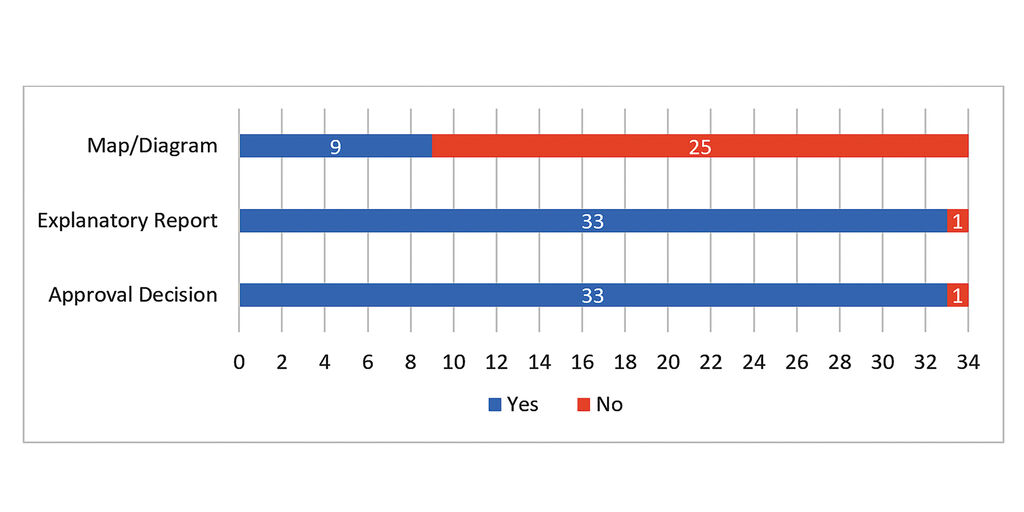 |
| Figure 1: Number of provinces disclosing land related documents online as part of their general master plans |
On completeness, only nine out of 34 provinces (26.5 per cent) disclosed a complete document set - comprising the approval decision, the explanatory report, and spatial maps/diagrams. These top-performing jurisdictions are Ha Noi, Ho Chi Minh City, Hai Phong, Dong Thap, Lang Son, An Giang, Nghe An, Son La and Quang Ngai. In 24 provinces, only two of the three documents were available for public view: planning information but incomplete records (for example, a decision and a map without the explanatory report, or the reverse). This limits citizens’ ability to check, understand and use planning information.
Concerning timeliness, statutory compliance regarding publication deadlines remained split. Of the 33 provinces where general master plans or provincial master plans were found, 17 disclosed their approval decisions and explanatory reports online on time (within 15 working days of approval), 14 posted late, and two could not be determined because of unavailable information. As for planning maps, of the nine provinces where planning maps or land-use orientation diagrams were found, three were published on time, three published late, and three lacked date tracking data.
With regard to ease of access and formats, dedicated disclosure folders were present in 32 out of 34 provinces (only Dong Nai and Thai Nguyen lacked dedicated planning/access folders). However, location consistency varied: 21 provinces posted approval decisions inside dedicated folders, while 12 placed them in general news or administrative sub-sections. Also, document formats were mostly accessible for textual records (22 provinces provided approval decisions and 24 provided reports in editable Word or readable PDF formats). Conversely, mapping usability was poor: of the nine provinces publishing maps, only three offered interactive online mapping systems (e.g., Khanh Hoa, Ho Chi Minh City, Da Nang), while six uploaded non-interactive PDF or static image files.
Disclosure of land-use master plans, general master plans and urban and rural plans of CPCs
The review of 3,321 CPCs’ portals reveals system-wide gaps in terms of the availability of documents, the timeliness of publication and ease of access.
The availability of information from a user-centred perspective is an important aspect of access. However, as Figure 2 reveals, online disclosure of land related planning documents on CPCs’ portals remains low. Of all 3,321 CPCs’ portals reviewed, only 8.9 per cent publicised their approval decisions, 6.4 per cent made the associated explanatory reports available, and 6.7 per cent disclosed planning maps. Over 90 per cent of CPCs did not make any such formal documents available online. Among CPCs’ portals where documents were found, a large share of the documents dated from before the merger. Of the 297 CPCs’ sites where approval decisions were located, the 217 where explanatory reports were located, and the 224 where maps were identified, the proportions of CPCs with pre-merger files accounted for 51.2 per cent, 59.2 per cent, and 62.1 per cent, respectively.
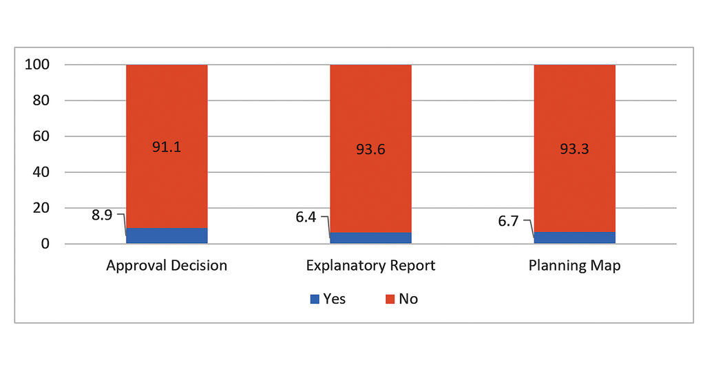 |
| Figure 2: Percentage of land-related planning documents |
There were severe deficits in document completeness. The review findings indicate that of the 3,321 CPCs reviewed, only 108 (3.3 per cent) provided a complete set of planning documentation (including an approval decision, an explanatory report and a planning map). Another 122 (3.7 per cent) had posted two of the three documents on their portals, and 164 (4.9 per cent) had only one. While selected provinces - including Thanh Hoa, Ninh Binh, Gia Lai, Dak Lak, and Thai Nguyen - showed relatively higher proportions of CPCs’ portals where all required types of documents were found, the share of these higher-performing communes remained below 10 per cent.
Regarding timeliness of information disclosure, as Figure 3 shows, among the nearly 300 CPCs whose portals documents were found, 47.1 per cent have published approval decisions, 32.9 per cent have published explanatory reports, and 17.4 per cent have published maps on time. The percentage of CPCs that published the documents identified above beyond the due date were 29 per cent (for approval decisions), 25.4 per cent (for explanatory reports) and 13.8 per cent (for planning maps). For a significant proportion of CPCs, the publication date or status of the documents could not be determined, especially maps, for which a determination would not be made in 54 per cent of cases.
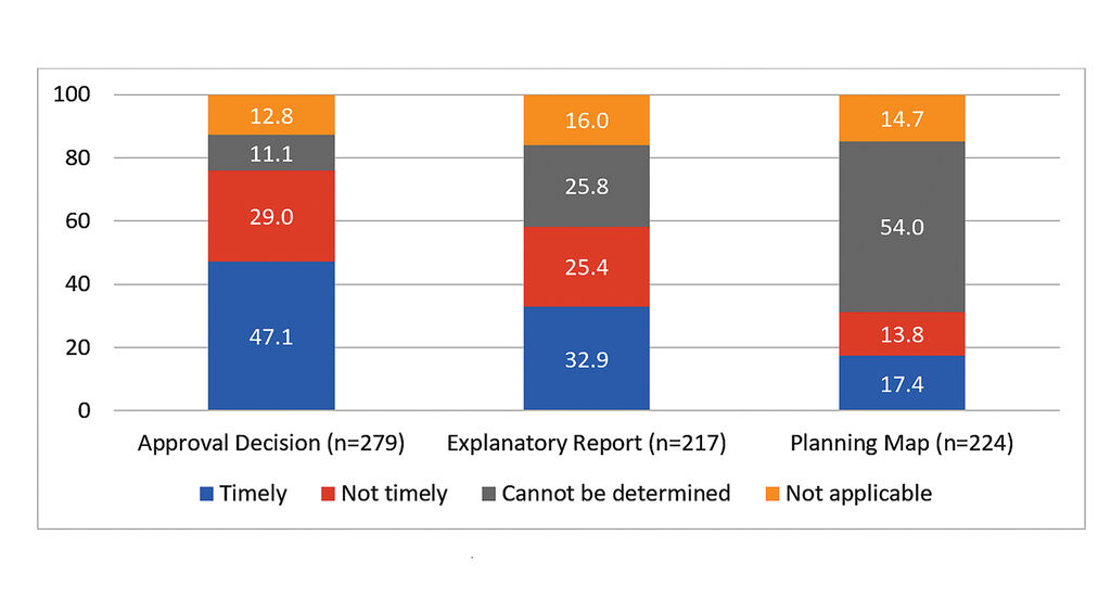 |
| Figure 3: Percentage of commune People’s Committees with documents published on time |
With regard to ease of access and usability, the review findings reveal barriers facing citizens due to information architecture on commune portals. Among the nearly 300 CPCs where disclosed documents were located on their portals, 64 per cent maintained dedicated disclosure folders for planning, access to information or general information. However, within this group, only 6.3 per cent had these dedicated folders organised by year or document type, while the remaining 93.7 per cent published the documents in an unstructured, uncategorised way.
Figure 4 further illustrates the barrier to locating the documents within dedicated folders on the portals/pages of CPCs remains limited. Among the CPCs where documents were retrieved, about 50 per cent have published approval decisions and explanatory reports in dedicated folders, whereas 43.3 per cent do so for planning maps.
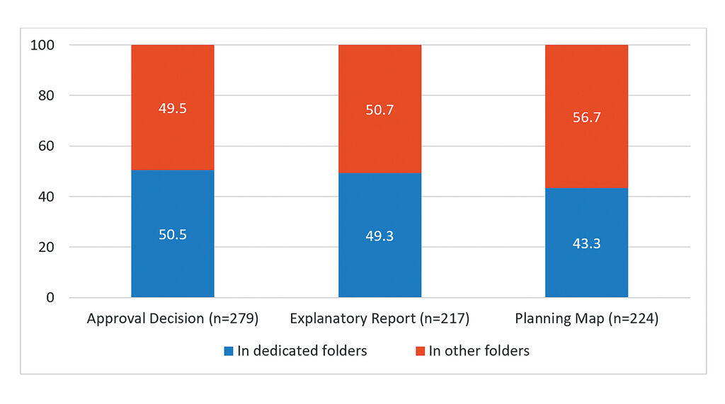 |
| Figure 4: Percentage of commune People’s Committees with documents found in dedicated folders on commune portals |
Documents formats were generally adequate in the case of approval decisions and explanatory reports, although some formats still limited their use. Issues with usability lie with planning maps. As Figure 5 reveals, of the 224 CPCs publishing the planning maps, 79.5 per cent uploaded static, non-interactive PDF or image files (including simple photographs of physical paper maps). Only 18.8 per cent offered interactive digital mapping, while 1.8 per cent required specialised, non-standard software installations.
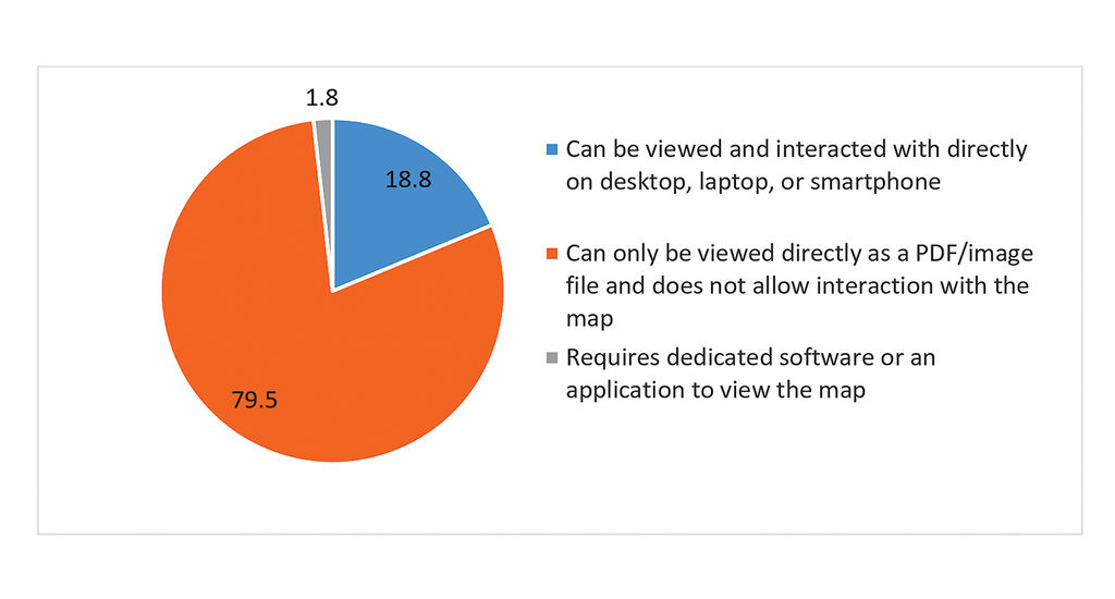 |
| Figure 5: Ability to view and interact with planning maps (per cent) |
Disclosure of initial provincial land pricing frames
The audit also examined provincial compliance with publishing initial 2026 land pricing frames under Article 159 of the Land Law. Its findings reveal that 25 out of 34 provinces disclosed the documents on their PPCs’ portals. For the other nine provinces,[3] no information on initial land pricing frames was found on their portals at the time of the review. Figures 6 and 7 show that, among the 25 provinces’ portals where the price frames were found, 11 published them on time (on or before January 1, 2026); 11 published them late; and three provinces lacked traceable disclosure dates.[4]
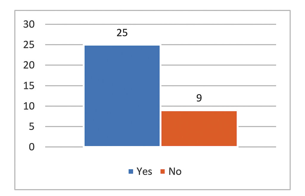 |
| Figure 6: Number of provinces that disclosed their land pricing frames (per cent) |
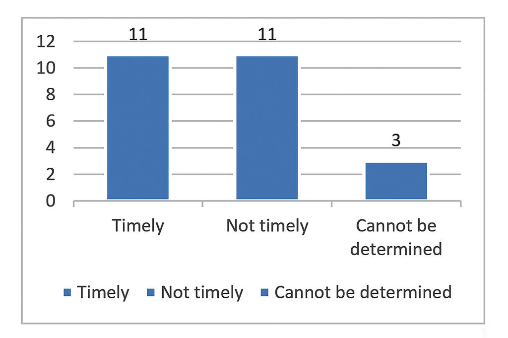 |
| Figure 7: Number of provinces that disclosed their land pricing frames on time (per cent) |
Furthermore, PPCs organised the information on their portals in different ways. Among 25 provinces that disclosed their initial land pricing frames, nine posted this document in a dedicated land price folder; eight posted it in other folders, such as access to information, announcements, or official gazettes; and eight made it available elsewhere on the portals. Land pricing frames posted in the official gazette section of PPCs’ portals also raise a timing issue. Gazettes are usually issued periodically, so documents published through them tend to appear later than those posted directly in disclosure or access-to-information folders.
File format is a technical feature, but it can also be used as an indicator of information usability. Of the 25 provinces that disclosed their initial land pricing frames, 21 provinces made them available in Microsoft Word or PDF formats that are easy to read or convert to Word; and four provinces used scanned PDFs or image files.
Adjusted or supplementary 2026 land pricing frames were found on the PPC portals of 11 provinces. Among these, only three were disclosed on time (within five working days of the signing of the approval decision). One province posted it in a land pricing frame folder, and nine posted it in folders such as access to information, the official gazette, or announcements. All 11 provinces used Word or PDF files that are easy to convert, and all of the lists could be viewed online.
Suggested ways forward
The review highlights progress at the provincial level in making legal decisions and explanatory reports available online. However, systemic challenges remain - particularly regarding the availability of spatial planning maps, commune-level document disclosure, and digital system usability. To bridge the gap between statutory guarantees and actual public access to land information, structural reforms across five key policy areas are recommended:
(i) Strengthening legal framework and disclosure standards;
(ii) Enforcing open GIS technical and data interoperability standards;
(iii) Standardising provincial portal architecture;
(iv) Establishing and updating commune-level land information channels; and,
(v) Implementing oversight, monitoring and inclusive access of land information disclosure.
Strengthening the legal framework and disclosure standards
The regulations governing the disclosure obligations of competent state authorities and citizens’ rights to access land information should continue to be maintained and further strengthened in the coming period. Further revision and refinement by the National Assembly and the Government of regulations on the disclosure of and access to land information will be instrumental in establishing a unified disclosure standard.
Enhanced regulations should clearly define the essential information to be disclosed, required documentation, methods of disclosure, timelines for publication and updating, as well as the responsibilities of authorities at each level of government. They should also clarify the relationship between disclosure obligations as enshrined in the laws on land, planning, and access to information, supporting harmonisation and thereby narrowing the gap between legal requirements for disclosure and citizens’ actual ability to access information.
Developing common technical standards and strengthening interoperability of planning and land data
The Government and relevant ministries and agencies should establish open technical standards requiring land data to be published in machine-readable, searchable, downloadable, and spatial formats. Planning dossiers must include approval decisions, reports, and maps as linked data packages. Technical infrastructure should be upgraded to support property lookup by map sheet, land parcel number, and geographic coordinates.
At the same time, it is also recommended that interoperability among land databases, land-use planning databases, and urban and rural planning databases should be strengthened to enable citizens to identify planning information relevant to a specific parcel of land.
Standardising provincial portals’ architecture
PPCs should define and standardise land information corners on their portals with clear direction to where such documents are posted (on e-gazettes, open data systems, or specialised GIS platforms). The portals should provide convenient access points through which citizens can readily locate planning dossiers and land pricing frames. The land information on the portals should be organised in a consistent manner, with direct links to relevant documents, clear indication of publication and update dates, and complete cross-linking among all components of each dossier.
During the transition period following the administrative restructuring, access to documents relating to administrative units that existed prior to provincial merger should be maintained, with clear guidance on their relationship to current administrative boundaries, names, and planning dossiers.
Establishing and updating commune-level land information channels
CPCs should establish a structured, searchable, and consistently maintained land information disclosure corner on their portals, rather than just announcing planning disclosure meetings. For each planning scheme subject to disclosure, attention should be given to the completeness of the dossier, including the approval decision, explanatory report, and map as required by law, together with the publication date, validity status, and update information.
Where dossiers are managed by provincial-level authorities or other agencies, clear links or guidance and means of accessing the relevant information should be provided on CPCs’ portals, so that citizens do not have to search across multiple systems themselves.
Implementing oversight, monitoring and inclusive access of land information disclosure
For the National Assembly and People’s Councils at all levels, oversight of land information disclosure should be incorporated into regular or ad-hoc monitoring of the implementation of the 2026 Law on Access to Information and related laws.
The Government, and ministries in charge of planning, land administration and access to information, should institute an empirical evaluation framework to audit local government compliance. Institutional performance should be evaluated not merely on whether a planning-related document is uploaded, but on whether citizens can successfully locate, understand, and use the information.
Finally, in line with the 2026 Law on Access to Information, local authorities, especially at the commune level, must maintain offline and alternative disclosure channels - including physical postings and public assistance desks - to serve persons with disabilities, ethnic minority communities, and residents in remote regions facing digital access barriers.-
[1] This article is an extract from the Summary Report “Review of Local Governments’ Public Disclosure of Land Use Master Plans and Land Pricing Frameworks Online in 2026” being commissioned by CDISE, VESS, Real-Time Analytics and UNDP from August to December 2026. Available [in Vietnamese] at: https://papi.org.vn/danh-gia-viec-thuc-hien-cong-khai-thong-tin-quy-hoach-ke-hoach-su-dung-dat-va-bang-gia-dat-cua-chinh-quyen-dia-phuong-nam-2026/.
[2] For more information, see https://papi.org.vn/eng/sang-kien-papi/ and at https://www.congkhaithongtindatdai.info/.
[3] Gia Lai, Tuyen Quang, Cao Bang, Dien Bien, Bac Ninh City, Lam Dong, Thanh Hoa, Tay Ninh and Thai Nguyen.
[4] Pursuant to Article 159.3 of the Land Law and guidance in Article 8.2 of Decree 151/2025/ND-CP, provincial People’s Committees prepare the initial land pricing frames, to be published and applied from January 1, 2026.